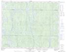
Maps showing Lac Tshiashk, Rivière-Mouchalagane; Caniapiscau, Quebec
Lac Tshiashk is a Lake located in Rivière-Mouchalagane; Caniapiscau, Quebec and has an elevation of 546 meters.
- Latitude: 51° 35' 17'' North (decimal: 51.5880556)
- Longitude: 69° 53' 39'' West (decimal: -69.8941667)
- Topography Feature Category: Lake
- Geographical Feature: Lac
- Canadian Province/Territory: Quebec
- Elevation: 546 meters
- Location: Rivière-Mouchalagane; Caniapiscau
- Atlas of Canada Locator Map: Lac Tshiashk
- GPS Coordinate Locator Map: Lac Tshiashk Lat/Long
Lac Tshiashk NTS Map Sheets