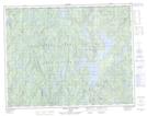
Maps showing Île de l'Embellie, Lac-Walker; Sept-Rivières, Quebec
Île de l'Embellie is a Island located in Lac-Walker; Sept-Rivières, Quebec.
- Latitude: 50° 50' 5'' North (decimal: 50.8347222)
- Longitude: 67° 10' 5'' West (decimal: -67.1680556)
- Topography Feature Category: Island
- Geographical Feature: Île / Ile
- Canadian Province/Territory: Quebec
- Location: Lac-Walker; Sept-Rivières
- Atlas of Canada Locator Map: Île de l'Embellie
- GPS Coordinate Locator Map: Île de l'Embellie Lat/Long
Île de l'Embellie NTS Map Sheets