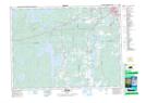
Maps showing Lac-Beauchastel, Rouyn-Noranda; Rouyn-Noranda, Quebec
Lac-Beauchastel is a Unincorporated area located in Rouyn-Noranda; Rouyn-Noranda, Quebec.
- Latitude: 48° 9' 43'' North (decimal: 48.1620311)
- Longitude: 79° 7' 16'' West (decimal: -79.1212020)
- Topography Feature Category: Unincorporated area
- Geographical Feature: Centre de villégiature
- Canadian Province/Territory: Quebec
- Location: Rouyn-Noranda; Rouyn-Noranda
- Atlas of Canada Locator Map: Lac-Beauchastel
- GPS Coordinate Locator Map: Lac-Beauchastel Lat/Long
Lac-Beauchastel NTS Map Sheets