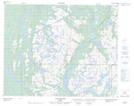
Maps showing Pointe Brandy, Petit-Mécatina; Minganie, Quebec
Pointe Brandy is a Cape located in Petit-Mécatina; Minganie, Quebec.
- Latitude: 51° 32' 11'' North (decimal: 51.5364423)
- Longitude: 57° 55' 21'' West (decimal: -57.9224154)
- Topography Feature Category: Cape
- Geographical Feature: Pointe
- Canadian Province/Territory: Quebec
- Location: Petit-Mécatina; Minganie
- Atlas of Canada Locator Map: Pointe Brandy
- GPS Coordinate Locator Map: Pointe Brandy Lat/Long
Pointe Brandy NTS Map Sheets