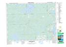
Maps showing Île Amik, Duparquet; Abitibi-Ouest, Quebec
Île Amik is a Island located in Duparquet; Abitibi-Ouest, Quebec.
- Latitude: 48° 29' 35'' North (decimal: 48.4930555)
- Longitude: 79° 14' 32'' West (decimal: -79.2422221)
- Topography Feature Category: Island
- Geographical Feature: Île / Ile
- Canadian Province/Territory: Quebec
- Location: Duparquet; Abitibi-Ouest
- Atlas of Canada Locator Map: Île Amik
- GPS Coordinate Locator Map: Île Amik Lat/Long
Île Amik NTS Map Sheets