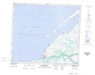
Maps showing Pointe Kajurtujaq, Baie-d'Hudson; Kativik, Quebec
Pointe Kajurtujaq is a Cape located in Baie-d'Hudson; Kativik, Quebec and has an elevation of 8 meters.
- Latitude: 55° 26' 00'' North (decimal: 55.4332073)
- Longitude: 77° 30' 7'' West (decimal: -77.5019557)
- Topography Feature Category: Cape
- Geographical Feature: Pointe
- Canadian Province/Territory: Quebec
- Elevation: 8 meters
- Location: Baie-d'Hudson; Kativik
- Atlas of Canada Locator Map: Pointe Kajurtujaq
- GPS Coordinate Locator Map: Pointe Kajurtujaq Lat/Long
Pointe Kajurtujaq NTS Map Sheets