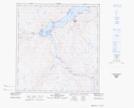
Maps showing Ruisseau Kuuguluk, Baie-d'Hudson; Kativik, Quebec
Ruisseau Kuuguluk is a River located in Baie-d'Hudson; Kativik, Quebec and has an elevation of 182 meters.
- Latitude: 62° 11' 54'' North (decimal: 62.1983592)
- Longitude: 75° 38' 3'' West (decimal: -75.6342287)
- Topography Feature Category: River
- Geographical Feature: Ruisseau
- Canadian Province/Territory: Quebec
- Elevation: 182 meters
- Location: Baie-d'Hudson; Kativik
- Atlas of Canada Locator Map: Ruisseau Kuuguluk
- GPS Coordinate Locator Map: Ruisseau Kuuguluk Lat/Long