Canada Topographic Maps

Lac du Gneiss Topo Maps

Topography maps and Latitude/Longitude Location

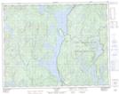
Maps showing Lac du Gneiss, Rivière-aux-Outardes; Manicouagan, Quebec

Lac du Gneiss is a Lake located in Rivière-aux-Outardes; Manicouagan, Quebec.

  • Latitude: 50° 59' 20'' North   (decimal: 50.9888825)
  • Longitude: 68° 0' 45'' West   (decimal: -68.0125046)
  • Topography Feature Category: Lake
  • Geographical Feature: Lac
  • Canadian Province/Territory: Quebec
  • Location: Rivière-aux-Outardes; Manicouagan
  • Atlas of Canada Locator Map: Lac du Gneiss
  • GPS Coordinate Locator Map: Lac du Gneiss Lat/Long

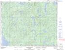
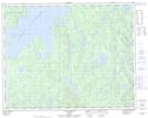
Lac du Gneiss NTS Map Sheets

022J13 Lac Fortin Topographic Map at 1:50,000 scale

022K16 Lac Mistachagagane Topographic Map at 1:50,000 scale

022N01 Lac Mathevet Topographic Map at 1:50,000 scale

022J Sept-Iles Topographic Map at 1:250,000 scale

022K Lac Berte Topographic Map at 1:250,000 scale

022N Reservoir Manicouagan Topographic Map at 1:250,000 scale

 
Buy Topographic Maps DVD
Newsletter Sign-up

Yes, I want to receive map store discounts.


Bookmark and Share