Maps showing Lac Shita, Lac-Jérôme; Minganie, Quebec
Lac Shita is a Lake located in Lac-Jérôme; Minganie, Quebec.
- Latitude: 50° 42' 56'' North (decimal: 50.7156234)
- Longitude: 62° 21' 47'' West (decimal: -62.3631606)
- Topography Feature Category: Lake
- Geographical Feature: Lac
- Canadian Province/Territory: Quebec
- Location: Lac-Jérôme; Minganie
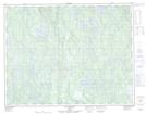
- Atlas of Canada Locator Map: Lac Shita
- GPS Coordinate Locator Map: Lac Shita Lat/Long
Lac Shita NTS Map Sheets