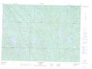
Maps showing Le Narrows, Lac-Nilgaut; Pontiac, Quebec
Le Narrows is a Channel located in Lac-Nilgaut; Pontiac, Quebec.
- Latitude: 46° 25' 58'' North (decimal: 46.4328358)
- Longitude: 76° 58' 48'' West (decimal: -76.9799994)
- Topography Feature Category: Channel
- Geographical Feature: Passe
- Canadian Province/Territory: Quebec
- Location: Lac-Nilgaut; Pontiac
- Atlas of Canada Locator Map: Le Narrows
- GPS Coordinate Locator Map: Le Narrows Lat/Long
Le Narrows NTS Map Sheets