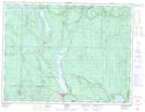
Maps showing Réserve indienne Red Rock 53, Thunder Bay, Ontario
Réserve indienne Red Rock 53 is a Indian Reserve located in Thunder Bay, Ontario.
- Latitude: 49° 4' 0'' North (decimal: 49.0667000)
- Longitude: 88° 18' 30'' West (decimal: -88.3082999)
- Topography Feature Category: Indian Reserve
- Geographical Feature: Réserve indienne
- Canadian Province/Territory: Ontario
- Location: Thunder Bay
- Atlas of Canada Locator Map: Réserve indienne Red Rock 53
- GPS Coordinate Locator Map: Réserve indienne Red Rock 53 Lat/Long