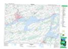
Maps showing Réserve indienne Tyendinaga 38, Hastings, Ontario
Réserve indienne Tyendinaga 38 is a Indian Reserve located in Hastings, Ontario.
- Latitude: 44° 11' 30'' North (decimal: 44.1916999)
- Longitude: 77° 9' 3'' West (decimal: -77.1508000)
- Topography Feature Category: Indian Reserve
- Geographical Feature: Réserve indienne
- Canadian Province/Territory: Ontario
- Location: Hastings
- GPS Coordinate Locator Map: Réserve indienne Tyendinaga 38 Lat/Long
Réserve indienne Tyendinaga 38 NTS Map Sheets