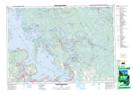
Maps showing Ardiluan Island, Ontario
Ardiluan Island is a Island located in Ontario.
- Latitude: 44° 54' 8'' North (decimal: 44.9021999)
- Longitude: 79° 51' 13'' West (decimal: -79.8535999)
- Topography Feature Category: Island
- Geographical Feature: Island
- Canadian Province/Territory: Ontario
- GPS Coordinate Locator Map: Ardiluan Island Lat/Long
Ardiluan Island NTS Map Sheets