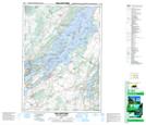
Maps showing Beaver Meadow Creek, Leeds, Ontario
Beaver Meadow Creek is a River located in Leeds, Ontario and has an elevation of 91 meters.
- Latitude: 44° 21' 52'' North (decimal: 44.3644444)
- Longitude: 76° 0' 41'' West (decimal: -76.0113888)
- Topography Feature Category: River
- Geographical Feature: Creek
- Canadian Province/Territory: Ontario
- Elevation: 91 meters
- Location: Leeds
- Atlas of Canada Locator Map: Beaver Meadow Creek
- GPS Coordinate Locator Map: Beaver Meadow Creek Lat/Long
Beaver Meadow Creek NTS Map Sheets