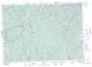
Maps showing Big Runway Island, Haliburton, Ontario
Big Runway Island is a Island located in Haliburton, Ontario and has an elevation of 355 meters.
- Latitude: 44° 53' 36'' North (decimal: 44.8933333)
- Longitude: 78° 6' 58'' West (decimal: -78.1161111)
- Topography Feature Category: Island
- Geographical Feature: Island
- Canadian Province/Territory: Ontario
- Elevation: 355 meters
- Location: Haliburton
- Atlas of Canada Locator Map: Big Runway Island
- GPS Coordinate Locator Map: Big Runway Island Lat/Long
Big Runway Island NTS Map Sheets