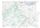
Maps showing Black Ash Creek, Simcoe; Grey, Ontario
Black Ash Creek is a River located in Simcoe; Grey, Ontario and has an elevation of 250 meters.
- Latitude: 44° 30' 25'' North (decimal: 44.5069444)
- Longitude: 80° 13' 54'' West (decimal: -80.2316666)
- Topography Feature Category: River
- Geographical Feature: Creek
- Canadian Province/Territory: Ontario
- Elevation: 250 meters
- Location: Simcoe; Grey
- Atlas of Canada Locator Map: Black Ash Creek
- GPS Coordinate Locator Map: Black Ash Creek Lat/Long
Black Ash Creek NTS Map Sheets