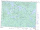
Maps showing Bland Bay, Sudbury, Ontario
Bland Bay is a Bay located in Sudbury, Ontario and has an elevation of 446 meters.
- Latitude: 47° 46' 21'' North (decimal: 47.7724999)
- Longitude: 83° 37' 6'' West (decimal: -83.6183333)
- Topography Feature Category: Bay
- Geographical Feature: Bay
- Canadian Province/Territory: Ontario
- Elevation: 446 meters
- Location: Sudbury
- Atlas of Canada Locator Map: Bland Bay
- GPS Coordinate Locator Map: Bland Bay Lat/Long