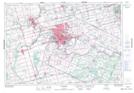
Maps showing Brantford, Brant, Ontario
Brantford is a City located in Brant, Ontario and has an elevation of 209 meters.
- Latitude: 43° 9' 25'' North (decimal: 43.1569444)
- Longitude: 80° 15' 27'' West (decimal: -80.2574999)
- Topography Feature Category: City
- Geographical Feature: City
- Canadian Province/Territory: Ontario
- Elevation: 209 meters
- Location: Brant
- Atlas of Canada Locator Map: Brantford
- GPS Coordinate Locator Map: Brantford Lat/Long
Brantford NTS Map Sheets