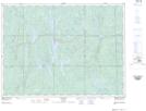
Maps showing Bridal Veil Falls, Timiskaming, Ontario
Bridal Veil Falls is a Falls located in Timiskaming, Ontario and has an elevation of 356 meters.
- Latitude: 47° 33' 7'' North (decimal: 47.5519444)
- Longitude: 80° 54' 37'' West (decimal: -80.9102777)
- Topography Feature Category: Falls
- Geographical Feature: Falls
- Canadian Province/Territory: Ontario
- Elevation: 356 meters
- Location: Timiskaming
- Atlas of Canada Locator Map: Bridal Veil Falls
- GPS Coordinate Locator Map: Bridal Veil Falls Lat/Long