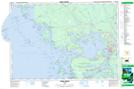
Maps showing Brooks Landing, Parry Sound, Ontario
Brooks Landing is a Unincorporated area located in Parry Sound, Ontario and has an elevation of 180 meters.
- Latitude: 45° 25' 58'' North (decimal: 45.4327777)
- Longitude: 80° 20' 11'' West (decimal: -80.3363888)
- Topography Feature Category: Unincorporated area
- Geographical Feature: Dispersed Rural Community
- Canadian Province/Territory: Ontario
- Elevation: 180 meters
- Location: Parry Sound
- Atlas of Canada Locator Map: Brooks Landing
- GPS Coordinate Locator Map: Brooks Landing Lat/Long
Brooks Landing NTS Map Sheets