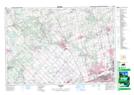
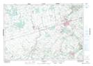
Maps showing Caledon Village, Peel, Ontario
Caledon Village is a Unincorporated area located in Peel, Ontario and has an elevation of 421 meters.
- Latitude: 43° 51' 45'' North (decimal: 43.8625000)
- Longitude: 79° 59' 40'' West (decimal: -79.9944444)
- Topography Feature Category: Unincorporated area
- Geographical Feature: Compact Rural Community
- Canadian Province/Territory: Ontario
- Elevation: 421 meters
- Location: Peel
- Atlas of Canada Locator Map: Caledon Village
- GPS Coordinate Locator Map: Caledon Village Lat/Long
Caledon Village NTS Map Sheets