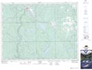
Maps showing Cane, Timiskaming, Ontario
Cane is a Unincorporated area located in Timiskaming, Ontario and has an elevation of 283 meters.
- Latitude: 47° 37' 47'' North (decimal: 47.6297222)
- Longitude: 80° 3' 41'' West (decimal: -80.0613888)
- Topography Feature Category: Unincorporated area
- Geographical Feature: Dispersed Rural Community
- Canadian Province/Territory: Ontario
- Elevation: 283 meters
- Location: Timiskaming
- Atlas of Canada Locator Map: Cane
- GPS Coordinate Locator Map: Cane Lat/Long