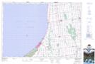
Maps showing Cantin Shoal, Huron, Ontario
Cantin Shoal is a Shoal located in Huron, Ontario.
- Latitude: 43° 21' 28'' North (decimal: 43.3577777)
- Longitude: 81° 44' 31'' West (decimal: -81.7419444)
- Topography Feature Category: Shoal
- Geographical Feature: Shoal
- Canadian Province/Territory: Ontario
- Location: Huron
- Atlas of Canada Locator Map: Cantin Shoal
- GPS Coordinate Locator Map: Cantin Shoal Lat/Long
Cantin Shoal NTS Map Sheets