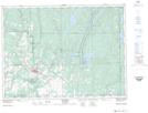
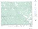
Maps showing Charlton, Timiskaming, Ontario
Charlton is a Unincorporated area located in Timiskaming, Ontario and has an elevation of 255 meters.
- Latitude: 47° 48' 36'' North (decimal: 47.8100000)
- Longitude: 80° 0' 17'' West (decimal: -80.0047222)
- Topography Feature Category: Unincorporated area
- Geographical Feature: Community
- Canadian Province/Territory: Ontario
- Elevation: 255 meters
- Location: Timiskaming
- Atlas of Canada Locator Map: Charlton
- GPS Coordinate Locator Map: Charlton Lat/Long
Charlton NTS Map Sheets