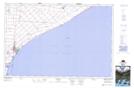
Maps showing Coatsworth Station, Kent, Ontario
Coatsworth Station is a Unincorporated area located in Kent, Ontario.
- Latitude: 42° 10' 10'' North (decimal: 42.1694000)
- Longitude: 82° 21' 18'' West (decimal: -82.3549999)
- Topography Feature Category: Unincorporated area
- Geographical Feature: Compact Rural Community
- Canadian Province/Territory: Ontario
- Location: Kent
- GPS Coordinate Locator Map: Coatsworth Station Lat/Long