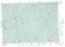
Maps showing Cope Falls, Haliburton, Ontario
Cope Falls is a Falls located in Haliburton, Ontario.
- Latitude: 44° 58' 1'' North (decimal: 44.9669444)
- Longitude: 78° 13' 40'' West (decimal: -78.2277777)
- Topography Feature Category: Falls
- Geographical Feature: Falls
- Canadian Province/Territory: Ontario
- Location: Haliburton
- Atlas of Canada Locator Map: Cope Falls
- GPS Coordinate Locator Map: Cope Falls Lat/Long
Cope Falls NTS Map Sheets