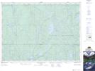
Maps showing Corley, Timiskaming, Ontario
Corley is a Geographical area located in Timiskaming, Ontario.
- Latitude: 47° 22' 15'' North (decimal: 47.3708333)
- Longitude: 80° 42' 54'' West (decimal: -80.7149999)
- Topography Feature Category: Geographical area
- Geographical Feature: Geographic Township
- Canadian Province/Territory: Ontario
- Location: Timiskaming
- Atlas of Canada Locator Map: Corley
- GPS Coordinate Locator Map: Corley Lat/Long
Corley NTS Map Sheets