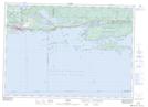
Maps showing The Cousins, Algoma, Ontario
The Cousins is a Island located in Algoma, Ontario and has an elevation of 176 meters.
- Latitude: 46° 4' 53'' North (decimal: 46.0813888)
- Longitude: 82° 48' 28'' West (decimal: -82.8077777)
- Topography Feature Category: Island
- Geographical Feature: Islands
- Canadian Province/Territory: Ontario
- Elevation: 176 meters
- Location: Algoma
- Atlas of Canada Locator Map: The Cousins
- GPS Coordinate Locator Map: The Cousins Lat/Long