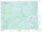
Maps showing Curtain Falls, Rainy River, Ontario
Curtain Falls is a Falls located in Rainy River, Ontario and has an elevation of 389 meters.
- Latitude: 48° 14' 15'' North (decimal: 48.2375000)
- Longitude: 91° 54' 21'' West (decimal: -91.9058333)
- Topography Feature Category: Falls
- Geographical Feature: Falls
- Canadian Province/Territory: Ontario
- Elevation: 389 meters
- Location: Rainy River
- Atlas of Canada Locator Map: Curtain Falls
- GPS Coordinate Locator Map: Curtain Falls Lat/Long
Curtain Falls NTS Map Sheets