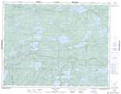
Maps showing Daniels Creek, Kenora, Ontario
Daniels Creek is a River located in Kenora, Ontario and has an elevation of 401 meters.
- Latitude: 49° 58' 4'' North (decimal: 49.9677777)
- Longitude: 93° 51' 46'' West (decimal: -93.8627777)
- Topography Feature Category: River
- Geographical Feature: Creek
- Canadian Province/Territory: Ontario
- Elevation: 401 meters
- Location: Kenora
- Atlas of Canada Locator Map: Daniels Creek
- GPS Coordinate Locator Map: Daniels Creek Lat/Long