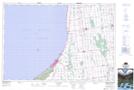
Maps showing Dashwood, Huron, Ontario
Dashwood is a Unincorporated area located in Huron, Ontario and has an elevation of 229 meters.
- Latitude: 43° 20' 46'' North (decimal: 43.3461111)
- Longitude: 81° 38' 7'' West (decimal: -81.6352777)
- Topography Feature Category: Unincorporated area
- Geographical Feature: Locality
- Canadian Province/Territory: Ontario
- Elevation: 229 meters
- Location: Huron
- Atlas of Canada Locator Map: Dashwood
- GPS Coordinate Locator Map: Dashwood Lat/Long
Dashwood NTS Map Sheets