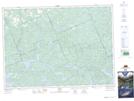
Maps showing Daventry, Nipissing, Ontario
Daventry is a Unincorporated area located in Nipissing, Ontario and has an elevation of 340 meters.
- Latitude: 46° 3' 39'' North (decimal: 46.0608333)
- Longitude: 78° 40' 7'' West (decimal: -78.6686111)
- Topography Feature Category: Unincorporated area
- Geographical Feature: Railway Point
- Canadian Province/Territory: Ontario
- Elevation: 340 meters
- Location: Nipissing
- Atlas of Canada Locator Map: Daventry
- GPS Coordinate Locator Map: Daventry Lat/Long