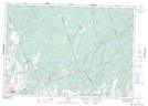
Maps showing Donahue Creek, Hastings, Ontario
Donahue Creek is a River located in Hastings, Ontario and has an elevation of 174 meters.
- Latitude: 44° 33' 57'' North (decimal: 44.5658333)
- Longitude: 77° 7' 53'' West (decimal: -77.1313888)
- Topography Feature Category: River
- Geographical Feature: Creek
- Canadian Province/Territory: Ontario
- Elevation: 174 meters
- Location: Hastings
- Atlas of Canada Locator Map: Donahue Creek
- GPS Coordinate Locator Map: Donahue Creek Lat/Long