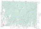
Maps showing East Hungerford, Hastings, Ontario
East Hungerford is a Unincorporated area located in Hastings, Ontario and has an elevation of 173 meters.
- Latitude: 44° 30' 9'' North (decimal: 44.5024999)
- Longitude: 77° 9' 14'' West (decimal: -77.1538888)
- Topography Feature Category: Unincorporated area
- Geographical Feature: Dispersed Rural Community
- Canadian Province/Territory: Ontario
- Elevation: 173 meters
- Location: Hastings
- Atlas of Canada Locator Map: East Hungerford
- GPS Coordinate Locator Map: East Hungerford Lat/Long