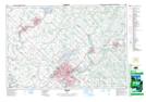
Maps showing Eden Mills, Wellington; Halton, Ontario
Eden Mills is a Unincorporated area located in Wellington; Halton, Ontario and has an elevation of 332 meters.
- Latitude: 43° 34' 43'' North (decimal: 43.5786111)
- Longitude: 80° 8' 36'' West (decimal: -80.1433333)
- Topography Feature Category: Unincorporated area
- Geographical Feature: Police Village
- Canadian Province/Territory: Ontario
- Elevation: 332 meters
- Location: Wellington; Halton
- Atlas of Canada Locator Map: Eden Mills
- GPS Coordinate Locator Map: Eden Mills Lat/Long