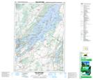
Maps showing Elliott Shoal, Leeds, Ontario
Elliott Shoal is a Shoal located in Leeds, Ontario.
- Latitude: 44° 29' 2'' North (decimal: 44.4838888)
- Longitude: 75° 49' 7'' West (decimal: -75.8186111)
- Topography Feature Category: Shoal
- Geographical Feature: Shoal
- Canadian Province/Territory: Ontario
- Location: Leeds
- Atlas of Canada Locator Map: Elliott Shoal
- GPS Coordinate Locator Map: Elliott Shoal Lat/Long
Elliott Shoal NTS Map Sheets