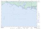
Maps showing Emery Reef, Parry Sound, Ontario
Emery Reef is a Shoal located in Parry Sound, Ontario.
- Latitude: 45° 54' 11'' North (decimal: 45.9030555)
- Longitude: 81° 0' 58'' West (decimal: -81.0161111)
- Topography Feature Category: Shoal
- Geographical Feature: Reef
- Canadian Province/Territory: Ontario
- Location: Parry Sound
- Atlas of Canada Locator Map: Emery Reef
- GPS Coordinate Locator Map: Emery Reef Lat/Long
Emery Reef NTS Map Sheets