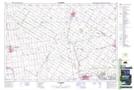
Maps showing Exeter, Huron, Ontario
Exeter is a Unincorporated area located in Huron, Ontario and has an elevation of 267 meters.
- Latitude: 43° 21' 18'' North (decimal: 43.3549999)
- Longitude: 81° 28' 50'' West (decimal: -81.4805555)
- Topography Feature Category: Unincorporated area
- Geographical Feature: Community
- Canadian Province/Territory: Ontario
- Elevation: 267 meters
- Location: Huron
- Atlas of Canada Locator Map: Exeter
- GPS Coordinate Locator Map: Exeter Lat/Long