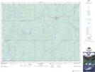
Maps showing The Forks, Timiskaming, Ontario
The Forks is a River feature located in Timiskaming, Ontario and has an elevation of 304 meters.
- Latitude: 47° 55' 27'' North (decimal: 47.9241666)
- Longitude: 80° 38' 56'' West (decimal: -80.6488888)
- Topography Feature Category: River feature
- Geographical Feature: Forks
- Canadian Province/Territory: Ontario
- Elevation: 304 meters
- Location: Timiskaming
- Atlas of Canada Locator Map: The Forks
- GPS Coordinate Locator Map: The Forks Lat/Long