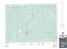
Maps showing Freeman, Timiskaming, Ontario
Freeman is a Unincorporated area located in Timiskaming, Ontario and has an elevation of 334 meters.
- Latitude: 47° 13' 41'' North (decimal: 47.2280555)
- Longitude: 79° 43' 38'' West (decimal: -79.7272222)
- Topography Feature Category: Unincorporated area
- Geographical Feature: Railway Point
- Canadian Province/Territory: Ontario
- Elevation: 334 meters
- Location: Timiskaming
- Atlas of Canada Locator Map: Freeman
- GPS Coordinate Locator Map: Freeman Lat/Long
Freeman NTS Map Sheets