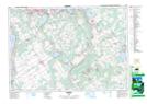
Maps showing French's Hill, Simcoe, Ontario
French's Hill is a Mountain located in Simcoe, Ontario and has an elevation of 210 meters.
- Latitude: 44° 35' 23'' North (decimal: 44.5897222)
- Longitude: 79° 55' 31'' West (decimal: -79.9252777)
- Topography Feature Category: Mountain
- Geographical Feature: Hill
- Canadian Province/Territory: Ontario
- Elevation: 210 meters
- Location: Simcoe
- Atlas of Canada Locator Map: French's Hill
- GPS Coordinate Locator Map: French's Hill Lat/Long
French's Hill NTS Map Sheets