Canada Topographic Maps

Georgian Bay Topo Maps

Topography maps and Latitude/Longitude Location

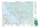
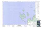
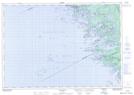
Maps showing Georgian Bay, Muskoka, Ontario

Georgian Bay is a Other municipal/district area - miscellaneous located in Muskoka, Ontario.

  • Latitude: 44° 59' 54'' North   (decimal: 44.9983333)
  • Longitude: 79° 50' 38'' West   (decimal: -79.8438888)
  • Topography Feature Category: Other municipal/district area - miscellaneous
  • Geographical Feature: Township Municipality
  • Canadian Province/Territory: Ontario
  • Location: Muskoka
  • Atlas of Canada Locator Map: Georgian Bay
  • GPS Coordinate Locator Map: Georgian Bay Lat/Long

Georgian Bay NTS Map Sheets

031D13 Penetanguishene Topographic Map at 1:50,000 scale

031E04 Lake Joseph Topographic Map at 1:50,000 scale

041A16 Christian Island Topographic Map at 1:50,000 scale

041H01 Sans Souci Topographic Map at 1:50,000 scale

031D Lake Simcoe Topographic Map at 1:250,000 scale

031E Huntsville Topographic Map at 1:250,000 scale

041A Owen Sound Topographic Map at 1:250,000 scale

041H Tobermory Topographic Map at 1:250,000 scale

 
Buy Topographic Maps DVD
Newsletter Sign-up

Yes, I want to receive map store discounts.


Bookmark and Share