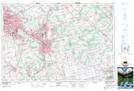
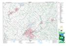
Maps showing Guelph, Wellington, Ontario
Guelph is a City located in Wellington, Ontario and has an elevation of 324 meters.
- Latitude: 43° 32' 9'' North (decimal: 43.5358333)
- Longitude: 80° 13' 44'' West (decimal: -80.2288888)
- Topography Feature Category: City
- Geographical Feature: City
- Canadian Province/Territory: Ontario
- Elevation: 324 meters
- Location: Wellington
- Atlas of Canada Locator Map: Guelph
- GPS Coordinate Locator Map: Guelph Lat/Long
Guelph NTS Map Sheets