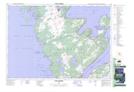
Maps showing Hattie Rock, Bruce, Ontario
Hattie Rock is a Shoal located in Bruce, Ontario and has an elevation of 176 meters.
- Latitude: 44° 50' 4'' North (decimal: 44.8344444)
- Longitude: 81° 22' 25'' West (decimal: -81.3736111)
- Topography Feature Category: Shoal
- Geographical Feature: Rock
- Canadian Province/Territory: Ontario
- Elevation: 176 meters
- Location: Bruce
- Atlas of Canada Locator Map: Hattie Rock
- GPS Coordinate Locator Map: Hattie Rock Lat/Long
Hattie Rock NTS Map Sheets