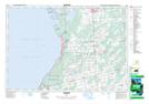
Maps showing Hawks Nest Point, Bruce, Ontario
Hawks Nest Point is a Cape located in Bruce, Ontario and has an elevation of 178 meters.
- Latitude: 44° 43' 37'' North (decimal: 44.7269444)
- Longitude: 81° 16' 51'' West (decimal: -81.2808333)
- Topography Feature Category: Cape
- Geographical Feature: Point
- Canadian Province/Territory: Ontario
- Elevation: 178 meters
- Location: Bruce
- Atlas of Canada Locator Map: Hawks Nest Point
- GPS Coordinate Locator Map: Hawks Nest Point Lat/Long