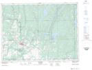
Maps showing Hell's Gate, Timiskaming, Ontario
Hell's Gate is a Rapids located in Timiskaming, Ontario and has an elevation of 242 meters.
- Latitude: 47° 47' 50'' North (decimal: 47.7972222)
- Longitude: 79° 53' 59'' West (decimal: -79.8997222)
- Topography Feature Category: Rapids
- Geographical Feature: Rapids
- Canadian Province/Territory: Ontario
- Elevation: 242 meters
- Location: Timiskaming
- Atlas of Canada Locator Map: Hell's Gate
- GPS Coordinate Locator Map: Hell's Gate Lat/Long
Hell's Gate NTS Map Sheets