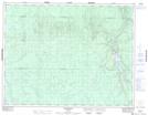
Maps showing Howells Lake, Cochrane, Ontario
Howells Lake is a Lake located in Cochrane, Ontario and has an elevation of 236 meters.
- Latitude: 49° 56' 24'' North (decimal: 49.9399999)
- Longitude: 81° 58' 48'' West (decimal: -81.9800000)
- Topography Feature Category: Lake
- Geographical Feature: Lake
- Canadian Province/Territory: Ontario
- Elevation: 236 meters
- Location: Cochrane
- Atlas of Canada Locator Map: Howells Lake
- GPS Coordinate Locator Map: Howells Lake Lat/Long
Howells Lake NTS Map Sheets