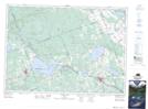
Maps showing Indian River, Renfrew, Ontario
Indian River is a River located in Renfrew, Ontario and has an elevation of 146 meters.
- Latitude: 45° 48' 54'' North (decimal: 45.8149999)
- Longitude: 77° 6' 55'' West (decimal: -77.1152777)
- Topography Feature Category: River
- Geographical Feature: River
- Canadian Province/Territory: Ontario
- Elevation: 146 meters
- Location: Renfrew
- Atlas of Canada Locator Map: Indian River
- GPS Coordinate Locator Map: Indian River Lat/Long
Indian River NTS Map Sheets