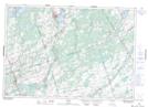
Maps showing Ivanhoe Station, Hastings, Ontario
Ivanhoe Station is a Unincorporated area located in Hastings, Ontario and has an elevation of 184 meters.
- Latitude: 44° 25' 5'' North (decimal: 44.4180555)
- Longitude: 77° 28' 1'' West (decimal: -77.4669444)
- Topography Feature Category: Unincorporated area
- Geographical Feature: Railway Point
- Canadian Province/Territory: Ontario
- Elevation: 184 meters
- Location: Hastings
- Atlas of Canada Locator Map: Ivanhoe Station
- GPS Coordinate Locator Map: Ivanhoe Station Lat/Long