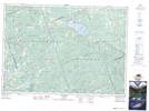
Maps showing Kinders Hill, Renfrew, Ontario
Kinders Hill is a Mountain located in Renfrew, Ontario and has an elevation of 386 meters.
- Latitude: 45° 24' 18'' North (decimal: 45.4050000)
- Longitude: 77° 26' 28'' West (decimal: -77.4411111)
- Topography Feature Category: Mountain
- Geographical Feature: Hill
- Canadian Province/Territory: Ontario
- Elevation: 386 meters
- Location: Renfrew
- Atlas of Canada Locator Map: Kinders Hill
- GPS Coordinate Locator Map: Kinders Hill Lat/Long